| |
Boundary Estimation |
Delineation of population boundaries is important for:
Real boundaries are irregular (Fig.1); they have "islands", "lakes", and "folds". Irregular boundaries are very difficult to analyze. For example, it is impossible to estimate the distance between boundaries in two consecutive years.
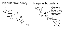 Fig.1. Regular and irregular boundaries A regular boundary can be defined as a boundary that crosses any perpendicular to the general boundary direction only once (Fig.1). In a mathematical sense, the regular boundary is a function in the rotated coordinate system with the X-axis parallel to the general boundary direction. It is possible to use a circular general boundary in a polar coordinate system. The problem is finding a regular boundary which fits the empiric boundary
in the best way. Sharov et al. (1995)
suggested a method of boundary estimation called "Best Cell Classification
Method" (BC):
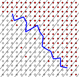 Fig. 2. Best cell classification method for estimating boundaries. Red circles are occupied grid cells, and empty circles are non-occupied. The blue line is the boundary.
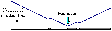
Fig. 3. Finding a point in a strip that minimizes the number of misclassified grid cells as occupied vs. non-occupied. This algorithm is not sensitive to the exact orientation of strips. That is why it is possible to draw them perpendicular to the general boundary direction determined by eye. General boundary direction can be estimated more accurately using the following iterative procedure:
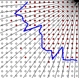 Fig. 4. Best cell classification method for estimating boundaries in polar coordinates. Red circles are occupied grid cells, and empty circles are non-occupied. The blue line is the boundary. The BC method has been used for more than six years in the Slow
the Spread project that is targeted at reducing the rate of population
expansion of the forest pest insect called gypsy moth (Lymantria dispar,
Lepidoptera: Lymantriidae). We used male moth captures in pheromone traps
to monitor the progression of the population front. Population boundaries
were estimated for thresholds of 1, 3, 10, 30, 100, and 300 moths/trap.
ReferencesSharov A.A., E.A. Roberts, A.M. Liebhold, and F.W. Ravlin. 1995. Gypsy moth (Lepidoptera: Lymantriidae) spread in the Central Appalachians: Three methods for species boundary estimation. Environ. Entomol. 24: 1529-1538. Get a reprint (PDF)Sharov, A. A., B. C. Pijanowski, A. M. Liebhold, and S. H. Gage. 1999. What affects the rate of gypsy moth (Lepidoptera: Lymantriidae) spread in Michigan: winter temperature or forest susceptibility? J. Agric. and Forest Entomol. 1: 37-45. You can download software here. It contains executables for DOS and the C-code. Also it has several tools that may be helpful. If you use this program, please, acknowledge Alexei Sharov and reference the paper indicated above:
For more information, please contact Patrick Tobin or Andy Roberts Maintained By Jiang Wu |
 Back to STS Decision-Support System