


Click near the border to see a neghboring map
Click on treatment blocks (red) to see details
|
|
Click near the border to see a neghboring map Click on treatment blocks (red) to see details |


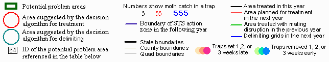

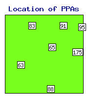
State Area Distance N Max Max Backgr. Priority Delimit Action Action Comment PPA ID sqkm km traps catch before moths index index recommended taken |
WI- 63 1 9.7 1 7 14 0.545 2.09 0.29 - - WI- 65 1 -1.5 1 26 26 0.857 1.55 0.34 - treat WI- 83 1 16.0 1 7 52 0.640 3.26 0.26 delimit - WI- 88 4 -14.0 2 33 37 0.757 0.00 0.32 - treat WI- 91 3 -2.4 2 22 150 1.055 0.33 0.36 - - WI- 95 1 -12.0 1 15 200 1.294 0.00 0.32 - - WI-175 5 -17.5 1 409 825 1.260 2.51 0.16 - treat |
| ID = | Identification number of the potential problem area (see the map). |
| Distance = | Distance from the beginning of the STS action zone, km. Negative distance means that the PPA is in the monitoring zone. |
| N traps = | Number of traps in the problem area. |
| Max catch = | Maximum number of moths captured within the problem area. |
| Max before = | Maximum number of moths captured in a 3-km neighborhood in the previous year. |
| Priority index = | Shows the priority for STS action (either treatment or delimiting). |
| Delimit index = | Shows how well the area was delimited in the previous year. |
| Backgr. moths = | Mean log moth counts in a 25-km neighborhood. |
See details in: Decision algorithm explained.
 Home
Home